- General Info
- Demographics
- Education and Employment
- Valuation and Taxes Levied
- State Senators
- History
- County Programs
- Other Information
Communities & Development
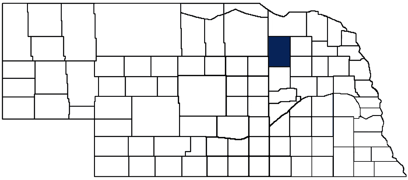
Antelope County Seat: Neligh
Total County Population: 6,352
- Cities (pop. & class): Elgin (706 • 2nd Class), Neligh (1,551 • 2nd Class), Tilden (Antelope Co. portion) (294 • 2nd Class)
- Villages (pop.): Brunswick (159), Clearwater (327), Oakdale (268), Orchard (351), Royal (55)
- Unincorporated Population (% of county pop.): 2,935 (46%) 2025
Land Development (% of total land in county):
- Agriculture: 88%
- By method: Irrigated (row crop/grain/forage) (56%), Pasture (pure grassland) (19%), Dryland (row crop/grain/forage) (13%)
- By commodity: Corn 39%, Soybeans 24%, Livestock (grassland) 21%, Alfalfa 3%, Popcorn 1%, plus some wetlands (3%) and some wooded grazing land (3%) and minus public grassland/wetlands and reserve
- Residential, Commercial, Industrial, Conservation Reserve & Exempt (combined): 10%
- Timber: 2% Note: method & commodity total percentages each equal agriculture's 88%; Neb. Dept. of Rev. & USDA 2022
County Offices
Courthouse Address and Hours:
501 Main Street
Neligh, Nebraska 68756
M-F 8:00 am - 4:30 pm
Complete list of county board members
County Board Meetings: 1st & 2nd Tuesday
View the County's Government Maps
NACO District: Northeast
Click for a live look at Antelope County (northwest of Brunswick)
General
Population: 6,352
Land area (sq. mi.): 857.16
Population per square mile: 7.4
Race & Age
Race 2024
White: 92.8%
African American: 0.8%
American Indian: 0.1%
Asian: 0.2%
Hispanic: 4.0%
Native Hawaiian and Pacific Islander: 0.0%
Two or More Races: 1.5%
Age 2024
0-17: 24.8%
18-64: 50.9%
65+: 24.5%
Households
Total households: 2,636 2024
With one child: 270 2023
With 2+ children: 500 2023
With seniors (65+): 470 2023
Socioeconomics
Median household income: $66,105 2024
% of population in poverty: 11.4% 2024
# of housing units: 3,149 2024
Owner-occupied rate: 74.5% 2024
Median home price: $135,680 Q4 2025
2025 building permits for detached single family homes: 18
2025 building permits for non-detached housing units: 0 (townhouse, duplex, or apt. unit)
Technology
Access to broadband (100 Mbps via fiber or cable model): 80.6% 2025
Sources: National Association of Realtors, Nebraska Department of Revenue, Nebraska Legislature, Nebraska Library Commission, U.S. Bureau of Economic Analysis, U.S. Census Bureau (building permits), U.S. Census Bureau (demographics), U.S. Census Bureau (municipalities)
Employment, Schools, and Child Care
Unemployment rate: 3.3% February 2026
County Employment Website: https://antelopecounty.nebraska.gov/available-positions
High school graduate or higher: 93.5% 2024
School Districts: Creighton Community Public Schools, Elgin Public Schools, Elkhorn Valley Schools, Neligh-Oakdale Schools, Plainview Public Schools, Summerland Public Schools
Bachelor's degree or higher: 20.5% 2024
Community College Service Area: Northeast Community College
Countywide child care capacity: 15 providers; 238 children 2026
Find child care: For a list of child care providers in your zip code, visit Nebraska DHHS or the Nebraska Resource and Referral System.
Antelope County Economy
Annual Gross Domestic Product (GDP): $776,573,000 2024
Nonfarm Small Business Receipts: $113,108,343 2023
Nonfarm Wage Income: $118,373,000 2022
Farm & Ranch Commodity Sales Receipts: $772,839,000 2022
Farm & Ranch Operations (Non-Sales) Receipts: $16,663,000 2022
- For components of nonfarm small business receipts, nonfarm wage income, and farm & ranch commodity sales and operations receipts, see "Notes" below.
Grain Elevators by Location (bushel capacity):
- Brunswick: J. E. Meuret (10,421,092)
- Copenhagen: J. E. Meuret (1,829,269)
- Elgin: CVA (2,666,000)
- Neligh: Battle Creek (3,765,118), Farmers Pride (3,600,000)
- Oakdale: Battle Creek (1,010,306)
- Orchard: J. E. Meuret (2,223,285)
- Royal: CVA (7,712,000)
- Tilden: CVA (3,186,000)
- (1 bushel = 56 lbs. corn/sorghum, 60 lbs. soybeans/wheat; % max. moisture = 18% beans, 15.5% corn, 14% sorghum/soybeans, 13.5% wheat)
Other Grain Purchasers:
- Elgin: Niewohner Farms
Railroad Miles: 24.15 main, 1.0 side
- Places with Railroad Service: Brunswick, Copenhagen, Orchard, Royal
Local Grain Market: Click for today's grain prices per bushel in Antelope County
Cattle Producers: 269
Crop Producers: 389
Dairy Producers: 7
Farmers Markets: Neligh Farmers Market (June - October, Saturdays 8:30 - 11 a.m.)
Electricity Providers: City of Neligh, Elkhorn Rural PPD, Nebraska PPD, North Central PPD, WAPA
Wind Turbines Operating (MW): 307 turbines (675,860 MW total)
Notes
- Nonfarm small business receipts are reported by partnerships and sole proprietorships. They do not include receipts reported by cooperative associations.
- Nonfarm wage income is reported based upon the wage earner's residential address; therefore, it also includes wages earned by Antelope County residents in other counties or states, but it excludes wages earned in Antelope County by residents of other counties or states.
- Nonfarm wage income excludes wages earned by anyone claimed as a dependent.
- Farm and ranch commodity sales receipts and operations receipts are reported based upon the farm or ranch owner's principal county of operations; therefore, those figures also include receipts reported by producers operating principally in Antelope County for their production in other counties or states, but the figures exclude receipts reported for production in Antelope County by producers operating principally in other counties or states.
Irrigation, Drinking Water, and Soils
Rural Irrigation/Livestock Wells: 2,965 2026
Rural Commercial/Industrial Wells: 12 2026
Rural Drinking Water Wells: 364 2026
Drinking Water Utility Connections: 1,840 Residential; 1,161 Commercial; 5 Industrial 2024
Irrigation/Livestock Wells per Square Mile: 3.46 2026
Surface Water Diversions (Irrigation): 87 2024
Sources: National Agricultural Statistics Service (USDA), Nebraska Cooperative Council, Nebraska Coordinating Commission for Postsecondary Education, Nebraska Department of Health and Human Services, Nebraska Department of Revenue, Nebraska Department of Transportation, Nebraska Office of the CIO, Nebraska Power Review Board, Nebraska Public Service Commission, U.S. Bureau of Economic Analysis, U.S. Bureau of Labor Statistics, U.S. Census Bureau, U.S. Energy Information Administration, U.S. Department of the Treasury (IRS), Warehouse and Commodity Management Division (USDA)
2024 Levies and Valuation
County levy rate: $0.261 per $100 of taxable valuation
County property taxes levied: $9,626,374
Total local government property taxes levied: $33,709,292
Total countywide taxable valuation: $3,692,633,277
Click here for all levy rates in Antelope County
County Levy and Taxation Laws
Levy limits
Since 1996, counties and other political subdivisions have been subject to the levy limits listed in Neb. Rev. Stat. § 77-3442 and Neb. Rev. Stat. § 77-3443.
Property tax statutes and regulations
Nebraska Revised Statutes (Chapter 77)
Nebraska Administrative Code (Title 350)
Local tax reductions, exemptions, and credits:
Neb. Rev. Stat. § 76-902(5)(a) (Deed "stamp tax" exemption): "The [stamp tax] shall not apply to: ... (5)(a) Deeds between spouses, between ex-spouses for the purpose of conveying any rights to property acquired or held during the marriage, or between parent and child, without actual consideration therefor."
Neb. Rev. Stat. § 77-201(2) (Agricultural land horticultural assessment): "Agricultural land and horticultural land as defined in section 77-1359 shall constitute a separate and distinct class of property for purposes of property taxation, shall be subject to taxation, unless expressly exempt from taxation, and shall be valued at seventy-five percent of its actual value, except that for school district taxes levied to pay the principal and interest on bonds that are approved by a vote of the people on or after January 1, 2022, such land shall be valued at fifty percent of its actual value."
Neb. Rev. Stat. § 77-6703(1) (Tax credit for school district taxes paid): "(1) For taxable years beginning or deemed to begin on or after January 1, 2020, under the Internal Revenue Code of 1986, as amended, there shall be allowed to each eligible taxpayer a refundable credit against the income tax imposed by the Nebraska Revenue Act of 1967 or against the franchise tax imposed by sections 77-3801 to 77-3807. The credit shall be equal to the credit percentage for the taxable year, as set by the department under subsection (2) of this section, multiplied by the amount of school district taxes paid by the eligible taxpayer during such taxable year."
Sources: Nebraska Department of Revenue
State Senator: Barry DeKay (District 40)
Committees:
- Agriculture
- General Affairs
- Natural Resources
- State-Tribal Relations (vice-chairperson)
- Justice Reinvestment Oversight
- Statewide Tourism and Recreation Water Access and Resource Sustainability
Map and statistics for Legislative District 40
Map of all districts in the Nebraska Unicameral Legislature

Antelope County History
Number of Registered Historic Places: 13
Year Authorized: 1871
Year Organized: 1871
Etymology: Local pronghorn antelope
In 1846, a colony of Mormons were among the first Europeans to pass through Antelope County. Twelve years later, when the area was first federally surveyed in 1858, the road which they had established on their way to Utah remained visible in the local soil. As can be seen at the links below, federally-contracted surveyors sketched the Mormon Road on their maps of what would become Bazile and Crawford townships.
Then sometime in the years that followed, according to local tradition, a posse pursuing a party of livestock thieves in northeast Nebraska ran low on food and survived by hunting the local pronghorn (although these animals are not true antelopes, they are known as such throughout North America, especially on the plains). So in 1871, when the State Legislature was drawing the fledging county’s boundaries and considering names, then-State Senator Leander Gerrard recalled the posse’s adventure and suggested the name Antelope County.
Oakdale initially became the county’s temporary seat as a result of a delayed messenger. John Neligh had been exploring the Elkhorn River Valley when he decided to purchase over 500 acres of land and persuade county officials to select his site as the county’s seat. He dispatched a messenger to declare his intentions to Antelope County voters, but the messenger got lost and failed to arrive in time for election day. Oakdale triumphed in the election as Antelope Valley’s seat, but the victory was short-lived. During the construction of the new courthouse, a fire burned the building to the ground, and afterwards, a new election for county seat was held. Neligh, a more centrally located site with an extremely vocal advocate in its founder, was selected by residents as the new county seat.
Among the hallmarks of early Antelope County were its fruit trees, including apple, plum, and cherry. The Neligh Mill was also a critical part of Antelope County, processing hundreds of thousands of bushels of wheat. Today, the mill is a popular tourist destination, as are the Ashfall Fossil Beds, home to well-preserved fossils of ancient hippos, rhinoceroses, horses, and camels. Grove Lake is also a popular destination for fishing, holding the state record for bluegill (2 lb. 13 oz.).
Antelope County Historical Township & Range Maps
Highlight an important program in your county in this space! Send an email to:
Local Highlights
License Plate Number: 26
Time Zone: Central
Number of Veterans: 352 2026
Zoned County: Yes
Number of County-Owned Bridges: 154
Election Data
General Election Turnout: 79% 2024
Total Registered Voters: 4,315 2024
Number of Precincts: 8 2022
Number of Election Day Polling Places: 8 2022
Land Area per Polling Place: 107.15 sq. miles
Intergovernmental Data
Emergency Mgt. Planning, Exercise and Training (PET) Region: Northeast
Natural Resource Districts: Upper Elkhorn NRD, Lower Elkhorn NRD
State Lands (acres): Grove Lake WMA (1,984.86), Hackberry Creek WMA (233.79), Red Wing WMA (320)
Sources: Nebraska Department of Transportation, Nebraska Emergency Management Agency, Nebraska Game & Parks Commission, Nebraska Legislature, Nebraska Office of the CIO, Nebraska Secretary of State, U.S. Department of Veterans Affairs, U.S. Election Assistance Commission, U.S. National Archives and Records Administration (eCFR)