
- General Info
- Demographics
- Education and Employment
- Valuation and Taxes Levied
- State Senators
- History
- County Programs
- Other Information
Communities and Development
Arthur County Seat: Arthur
Total County Population: 396
- Villages (pop.): Arthur (119)
- Unincorporated Pop. (% of county pop.): 277 (70%) 2025
Land Development (% of total land in county):
- Agriculture: 99%
- By method: Pasture (pure grassland) (96%), Irrigated (row crop/grain/forage) (2%), Dryland (row crop/grain/forage) (0%) • Total equals agriculture's % above
- By commodity: Livestock (grassland) 94%, Corn 1%, Alfalfa 1% • Total equals agriculture's % above, plus some wetlands (3%) and minus public grassland/wetlands and reserve
- Residential, Commercial, Industrial, Conservation Reserve & Exempt (combined): 1% 2022
County Offices
Courthouse Address and Hours:
205 First Street
Arthur, Nebraska 69121
M-F 8:00 am - 4:00 pm (MST)
Complete list of county board members
County Board Meetings: Last Few Days of Month
View the County's Government Maps
NACO District: West Central
General
Population: 396
Land area (sq. mi.): 715.15
Population per square mile: 0.6
Race and Age
Race 2024
White: 93.0%
African American: 0.0%
American Indian: 0.0%
Asian: 0.0%
Hispanic: 0.6%
Native Hawaiian and Pacific Islander: 1.0%
Two or More Races: 5.2%
Age 2024
0-17: 28.3%
18-64: 37.6%
65+: 27.8%
Households
Total households: 185 2024
With one child: 20 2023
With 2+ children: 30 2023
With seniors (65+): 30 2023
Socioeconomics
Median household income: $76,250 2024
% of population in poverty: 11.8% 2024
# of housing units: 232 2024
Owner-occupied rate: 68.4% 2024
Median home price: $197,570 Q4 2025
2025 building permits for detached single family homes: Data unavailable
2025 building permits for non-detached housing units: Data unavailable (townhouse, duplex, or apt. unit)
Technology
Access to broadband (100 Mbps via fiber or cable model): 99.3% 2025
Sources: National Association of Realtors, Nebraska Department of Revenue, Nebraska Legislature, Nebraska Library Commission, U.S. Bureau of Economic Analysis, U.S. Census Bureau (building permits), U.S. Census Bureau (demographics), U.S. Census Bureau (municipalities)
Employment and Schools
Unemployment rate: 2.8% February 2026
County Employment Website: https://nebraskacounties.org/nebraska-counties/county-employment-opportunities.html
High school graduate or higher: 98.8% 2024
Bachelor's degree or higher: 36.6% 2024
Community College Service Area: Mid-Plains Community College
School District: Arthur County Schools
Arthur County Economy
Annual Gross Domestic Product (GDP): $33,182,000 2024
Nonfarm Small Business Receipts: $6,187,470 2023
Nonfarm Wage Income: $4,906,000 2022
Farm & Ranch Commodity Sales Receipts: $39,338,000 2022
Farm & Ranch Operations (Non-Sales) Receipts: $1,665,000 2022
- For components of nonfarm small business receipts, nonfarm wage income, and farm & ranch commodity sales and operations receipts, see "Notes" below.
Local Grain Market: Click for today's grain prices per bushel in Arthur County
Cattle Producers: 79
- Pastureland Cash Rent (avg.): $24/acre/yr 2025
Crop Producers: 32
- Irrigated Land Cash Rent (avg.): $174/acre/yr 2025
Electricity Providers: PREMA, Wheat Belt PPD
Notes
- Nonfarm small business receipts are reported by partnerships and sole proprietorships. They do not include receipts reported by cooperative associations.
- Nonfarm wage income is reported based upon the wage earner's residential address; therefore, it also includes wages earned by Arthur County residents in other counties or states, but it excludes wages earned in Arthur County by residents of other counties or states.
- Nonfarm wage income excludes wages earned by anyone claimed as a dependent.
- Farm and ranch commodity sales receipts and operations receipts are reported based upon the farm or ranch owner's principal county of operations; therefore, those figures also include receipts reported by producers operating principally in Arthur County for their production in other counties or states, but the figures exclude receipts reported for production in Arthur County by producers operating principally in other counties or states.
Irrigation, Drinking Water, and Soils
Rural Irrigation/Livestock Wells: 521 2026
Rural Commercial/Industrial Wells: 1 2026
Rural Drinking Water Wells: 84 2026
Drinking Water Utility Connections: 0 2026
Irrigation/Livestock Wells per Square Mile: 0.73 2026
Click for real time:
Groundwater level data in Arthur County (15 mi. northeast of Arthur)
Click the section numbers in the grid below the map for annual groundwater levels.
Note: Geocodes in the map's squares are in the grid next to Township & Range (T&R).
Sources: National Agricultural Statistics Service (USDA), Nebraska Cooperative Council, Nebraska Coordinating Commission for Postsecondary Education, Nebraska Department of Health and Human Services, Nebraska Department of Revenue, Nebraska Department of Transportation, Nebraska Office of the CIO, Nebraska Power Review Board, Nebraska Public Service Commission, U.S. Bureau of Economic Analysis, U.S. Bureau of Labor Statistics, U.S. Census Bureau, U.S. Energy Information Administration, U.S. Department of the Treasury (IRS), Warehouse and Commodity Management Division (USDA)
2024 Levies and Valuations
County levy rate: $0.223 per $100 of taxable valuation
County property taxes levied: $636,579
Total local government property taxes levied: $3,180,061
Total countywide taxable valuation: $285,756,777
Click here for all levy rates in Arthur County
County Levy and Taxation Laws
Levy limits
Since 1996, counties and other political subdivisions have been subject to the levy limits listed in Neb. Rev. Stat. § 77-3442 and Neb. Rev. Stat. § 77-3443.
Property tax statutes and regulations
Nebraska Revised Statutes (Chapter 77)
Nebraska Administrative Code (Title 350)
Local tax reductions, exemptions, and credits:
Neb. Rev. Stat. § 76-902(5)(a) (Deed "stamp tax" exemption): "The [stamp tax] shall not apply to: ... (5)(a) Deeds between spouses, between ex-spouses for the purpose of conveying any rights to property acquired or held during the marriage, or between parent and child, without actual consideration therefor."
Neb. Rev. Stat. § 77-201(2) (Agricultural land horticultural assessment): "Agricultural land and horticultural land as defined in section 77-1359 shall constitute a separate and distinct class of property for purposes of property taxation, shall be subject to taxation, unless expressly exempt from taxation, and shall be valued at seventy-five percent of its actual value, except that for school district taxes levied to pay the principal and interest on bonds that are approved by a vote of the people on or after January 1, 2022, such land shall be valued at fifty percent of its actual value."
Neb. Rev. Stat. § 77-6703(1) (Tax credit for school district taxes paid): "(1) For taxable years beginning or deemed to begin on or after January 1, 2020, under the Internal Revenue Code of 1986, as amended, there shall be allowed to each eligible taxpayer a refundable credit against the income tax imposed by the Nebraska Revenue Act of 1967 or against the franchise tax imposed by sections 77-3801 to 77-3807. The credit shall be equal to the credit percentage for the taxable year, as set by the department under subsection (2) of this section, multiplied by the amount of school district taxes paid by the eligible taxpayer during such taxable year."
Sources: Nebraska Department of Revenue
State Senator: Paul E. Strommen (District 47)
Committees:
- Appropriations
- Legislature's Planning Committee
- Homeland Security Policy Group
- Statewide Tourism And Recreational Water Access and Resource Sustainability (LB406)
Map and statistics for Legislative District 47
Map of all districts in the Nebraska Unicameral Legislature

Arthur County History
Number of Registered Historic Places: 2
Year Authorized: 1913
Year Organized: 1913
Etymology: Chester Arthur (21st U.S. president)
Arthur County bears the distinction of being Nebraska’s last organized county. Originally part of McPherson County, Arthur County was truly the final frontier for expansion in Nebraska. The Kinkaid Act of 1904 stimulated additional settlement of the southern Sandhill region, which added nearly 2,000 residents between 1900 and 1910. The population increase spurred calls to partition McPherson County in half, as well as led to a new federal survey of the area as shown by the 1910-1913 township resurvey maps at the links below.
The Nebraska Legislature concurred in partitioning McPherson County and passed legislation authorizing the organization of Arthur County in 1913. The county was named after Chester A. Arthur, who became the 21st president of the United States following the assassination of President James A. Garfield in 1881.
Today, Arthur County retains strong ties to its proud history of self-sufficiency, frontier ingenuity, and local self-government. In the 2022 election, the county produced the highest voter turnout in the state with 76%. The map below, taken from the 1950 U.S. Census, displays election precincts established early in the county's history.
-
NORTHERN TOWNSHIPS
-
-------------------------------------------
-
MID-NORTHERN TOWNSHIPS
-
-------------------------------------------
-
MID-SOUTHERN TOWNSHIPS
-
-------------------------------------------
-
SOUTHERN TOWNSHIPS
-
-------------------------------------------
-
RESURVEY OF 1909 TO 1913
Arthur County Excellence
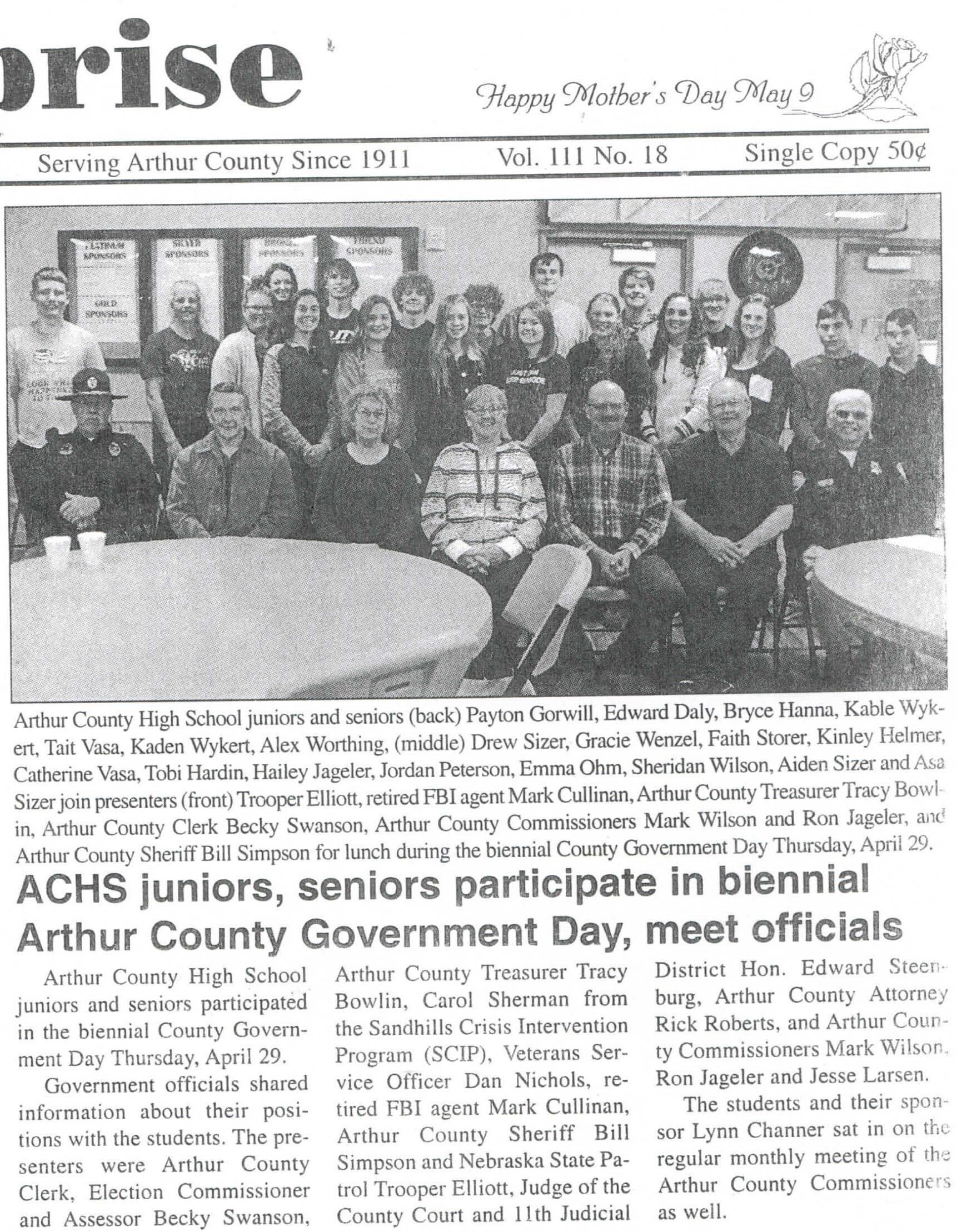
Every two years, the Arthur County Courthouse hosts local high school juniors and seniors for Local Government Day. County officials and employees eat lunch with the students and provide information about the important work done by the Arthur County government.
Local Highlights
License Plate Number: 91
Time Zone: Mountain
Number of Veterans: 30 2026
Zoned County: Yes
County Library: Arthur County Library
Election Data
General Election Turnout: 84% 2024
Total Registered Voters: 329 2024
Number of Precincts: 1 2022
Number of Election Day Polling Places: 1 2022
Land Area per Polling Place: 715.15 sq. miles
Intergovernmental Data
Emergency Mgt. Planning, Exercise and Training (PET) Region: North Central/Sandhills
Natural Resource District: Twin Platte NRD
Sources: Nebraska Department of Transportation, Nebraska Emergency Management Agency, Nebraska Game & Parks Commission, Nebraska Legislature, Nebraska Office of the CIO, Nebraska Secretary of State, U.S. Department of Veterans Affairs, U.S. Election Assistance Commission, U.S. National Archives and Records Administration (eCFR)

