
- General Info
- Demographics
- Education and Employment
- Valuation and Taxes Levied
- State Senators
- History
- County Programs
- Other Information
Communities and Development
Blaine County Seat: Brewster
Total County Population: 458
- Villages (pop.): Brewster (9), Dunning (85)
- Unincorporated Pop. (% of county pop.): 364 (79%) 2025
Land Development (% of total land in county):
- Agriculture: 95%
- By method: Pasture (pure grassland) (92%), Irrigated (row crop/grain/forage) (3%), Dryland (row crop/grain/forage) (0%) • Neb. Dept. of Rev. - total equals agriculture's %
- By commodity: Livestock (grassland) 92%, Alfalfa 1%, Corn 1% • USDA (NLCD) - equals agriculture's % plus some wetlands (4%) and minus public grassland/wetlands and reserve
- Residential, Commercial, Industrial, Conservation Reserve & Exempt (combined): 5% 2022
County Offices
Courthouse Address and Hours:
145 Lincoln Avenue
Brewster, Nebraska 68821
M-F 8:00 am - 4:00 pm
Complete list of county board members
County Board Meetings: 4th Wednesday
View the County's Government Maps
NACO District: West Central
West Central District Officers
General
Population: 458
Land area (sq. mi.): 710.69
Population per square mile: 0.6
Race & Age
Race 2024
White: 100%
African American: 0.0%
American Indian: 0.0%
Asian: 0.0%
Hispanic: 0.0%
Native Hawaiian and Pacific Islander: 0.0%
Two or More Races: 0.0%
Age 2024
0-17: 19.4%
18-64: 50.2%
65+: 31.9%
Households
Total households: 197 2024
With one child: 20 2024
With 2+ children: 30 2023
With seniors (65+): 40 2023
Socioeconomics
Median household income: $69,583 2024
% of population in poverty: 14.5% 2024
# of housing units: 301 2024
Owner-occupied rate: 65.8% 2024
Median home price: $121,720 Q4 2025
2025 building permits for detached single family homes: Data unavailable
2025 building permits for non-detached housing units: Data unavailable (townhouse, duplex, or apt. unit)
Technology
Access to broadband (100 Mbps via fiber or cable model): 80.8% 2025
Sources: National Association of Realtors, Nebraska Department of Revenue, Nebraska Legislature, Nebraska Library Commission, U.S. Bureau of Economic Analysis, U.S. Census Bureau (demographics), U.S. Census Bureau (municipalities)
Employment, Schools, and Child Care
Unemployment rate: 3.1% February 2026
County Employment Website: https://nebraskacounties.org/nebraska-counties/county-employment-opportunities.html
High school graduate or higher: 96.6% 2024
School Districts: Anselmo-Merna Public Schools, Loup County Public Schools, Sandhills Public Schools, Sargent Public Schools
Bachelor's degree or higher: 25.0% 2024
Community College Service Area: Mid-Plains Community College
Blaine County Economy
Annual Gross Domestic Product (GDP): $50,758,000 2024
Nonfarm Small Business Receipts: $12,565,950 2023
Nonfarm Wage Income: $6,030,000 2022
Farm & Ranch Commodity Sales Receipts: $34,191,000 2022
Farm & Ranch Operations (Non-Sales) Receipts: $1,222,000 2022
- For components of nonfarm small business receipts, nonfarm wage income, and farm & ranch commodity sales and operations receipts, see "Notes" below.
Cattle Producers: 82
- Pastureland Cash Rent (avg.): $19/acre/yr 2025
Crop Producers: 29
- Irrigated Land Cash Rent (avg.): $187/acre/yr 2025
Railroad Miles: 27.31 main, 0.80 side
- Places with Railroad Service: Dunning, Halsey
Electricity Provider: Custer PPD
Notes
- Nonfarm small business receipts are reported by partnerships and sole proprietorships. They do not include receipts reported by cooperative associations.
- Nonfarm wage income is reported based upon the wage earner's residential address; therefore, it also includes wages earned by Blaine County residents in other counties or states, but it excludes wages earned in Blaine County by residents of other counties or states.
- Nonfarm wage income excludes wages earned by anyone claimed as a dependent.
- Farm and ranch commodity sales receipts and operations receipts are reported based upon the farm or ranch owner's principal county of operations; therefore, those figures also include receipts reported by producers operating principally in Blaine County for their production in other counties or states, but the figures exclude receipts reported for production in Blaine County by producers operating principally in other counties or states.
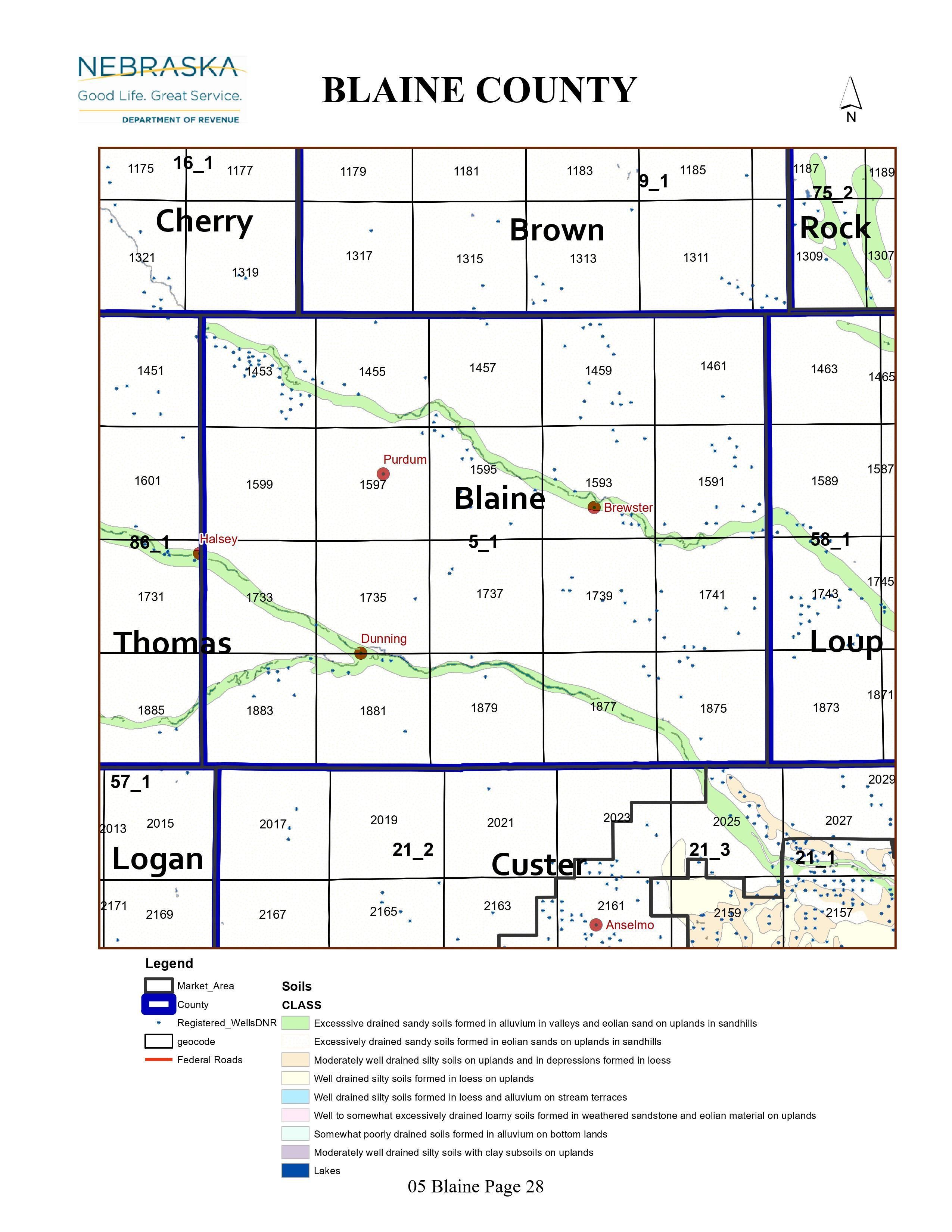
Irrigation, Drinking Water, and Soils
Rural Irrigation/Livestock Wells: 467 2026
Rural Commercial/Industrial Wells: 0 2024
Rural Drinking Water Wells: 45 2026
Drinking Water Utility Connections: 45 Residential; 0 Commercial; 0 Industrial 2024
Irrigation/Livestock Wells per Square Mile: 0.66 2026
Surface Water Diversions (Irrigation): 17 2024
Click for real time stream flow data in the
• Middle Loup River at Dunning (every 15 minutes)
• North Loup River at Brewster (every 15 minutes)
Click the section numbers in the grid below the map for annual groundwater levels.
Note: Geocodes in the map's squares are in the grid next to Township & Range (T&R).
Sources: National Agricultural Statistics Service (USDA), Nebraska Cooperative Council, Nebraska Coordinating Commission for Postsecondary Education, Nebraska Department of Health and Human Services, Nebraska Department of Revenue, Nebraska Department of Transportation, Nebraska Office of the CIO, Nebraska Power Review Board, Nebraska Public Service Commission, U.S. Bureau of Economic Analysis, U.S. Bureau of Labor Statistics, U.S. Census Bureau, U.S. Energy Information Administration, U.S. Department of the Treasury (IRS), Warehouse and Commodity Management Division (USDA)
2025 Levies and Valuation
County levy rate: $0.211 per $100 of taxable valuation
County property taxes levied: $812,534
Total local government property taxes levied: $3,362,146
Total countywide taxable valuation: $384,674,070
Federal PILT payment to Blaine County (FY2025): $35,561 regarding 10,722 federally-owned acres
Federal SRS payment to Blaine County (FY2025): $4,990.03 regarding the Nebraska National Forest
Click here for all levy rates in Blaine County
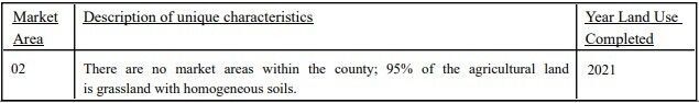
Agricultural Land Valuation Market Areas
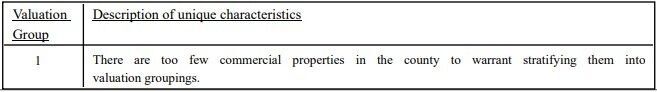
Commercial Land Valuation Groups
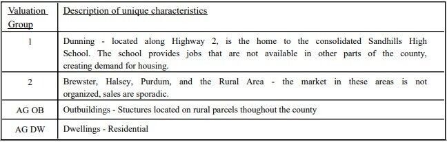
Residential Land Valuation Groups
County Levy and Taxation Laws
Levy limits
Since 1996, counties and other political subdivisions have been subject to the levy limits listed in Neb. Rev. Stat. § 77-3442 and Neb. Rev. Stat. § 77-3443.
Statutes and regulations
Nebraska Revised Statutes (Chapter 77)
Nebraska Administrative Code (Title 350)
Local tax reductions, exemptions, and credits:
Neb. Rev. Stat. § 76-902(5)(a) (Deed "stamp tax" exemption): "The [stamp tax] shall not apply to: ... (5)(a) Deeds between spouses, between ex-spouses for the purpose of conveying any rights to property acquired or held during the marriage, or between parent and child, without actual consideration therefor."
Neb. Rev. Stat. § 77-201(2) (Agricultural land and horticultural land valuation): "Agricultural land and horticultural land as defined in section 77-1359 shall constitute a separate and distinct class of property for purposes of property taxation, shall be subject to taxation, unless expressly exempt from taxation, and shall be valued at seventy-five percent of its actual value, except that for school district taxes levied to pay the principal and interest on bonds that are approved by a vote of the people on or after January 1, 2022, such land shall be valued at fifty percent of its actual value."
Neb. Rev. Stat. § 77-6703(1) (Tax credit for school district taxes paid): "(1) For taxable years beginning or deemed to begin on or after January 1, 2020, under the Internal Revenue Code of 1986, as amended, there shall be allowed to each eligible taxpayer a refundable credit against the income tax imposed by the Nebraska Revenue Act of 1967 or against the franchise tax imposed by sections 77-3801 to 77-3807. The credit shall be equal to the credit percentage for the taxable year, as set by the department under subsection (2) of this section, multiplied by the amount of school district taxes paid by the eligible taxpayer during such taxable year."
Sources: Nebraska Department of Revenue
State Senator: Tanya Storer (District 43)
Committees:
Map and statistics for Legislative District 43
Map of all districts in the Nebraska Unicameral Legislature

Blaine County History
Year Authorized: 1885
Year Organized: 1886
Etymology: James G. Blaine (Congressman, Senator, and President candidate)
Although named for the Republican Party's 1884 presidential candidate, Blaine County owes a greater debt to George Washington Brewster, who helped settle the area at great personal expense. While other homesteaders departed the region after surveying the soil quality and lacking rainfall, Brewster established his homestead near the North Loup River. Beginning in 1884, Brewster spent considerable money helping to build the town, including constructing a bridge and establishing a newspaper.
Ladora was originally selected as the county seat in 1886. However, in 1887, Blaine County held a general election, during which the town of Brewster became the county seat. The county set about constructing a courthouse that lasted for nearly twenty years before a fire forced construction of a new courthouse in 1907. That structure then enjoyed remodeling and the construction of an addition in the 1960’s and 70’s and now continues to serve Blaine County residents as their courthouse today.
Another important structure in Blaine County today is the Millburn Diversion Dam on the Middle Loup River, completed in 1956. It provides irritation for local farmers, as well as enjoyment downstream of the dam for canoers and kayakers.
Blaine County Historical Township & Range Maps
Highlight an important program in your county in this space! Send an email to:
Local Highlights
License Plate Number: 86
Time Zone: Central
Number of Veterans: 61 2026
Zoned County: No
Number of County-Owned Bridges: 17
Election Data
General Election Turnout: 83% 2024
Total Registered Voters: 354 2024
Number of Precincts: 1 2024
Number of Election Day Polling Places: 1 2024
Land Area per Polling Place (avg.): 710.69 sq. miles
Intergovernmental Data
Emergency Mgt. Planning, Exercise and Training (PET) Region: North Central/Sandhills
Natural Resource Districts: Upper Loup NRD
State Lands (acres): Milburn Dam WMA (672)
Sources: Nebraska Department of Transportation, Nebraska Emergency Management Agency, Nebraska Game & Parks Commission, Nebraska Legislature, Nebraska Office of the CIO, Nebraska Secretary of State, U.S. Department of Veterans Affairs, U.S. Election Assistance Commission, U.S. National Archives and Records Administration (eCFR)

