- General Info
- Demographics
- Education and Employment
- Valuation and Taxes Levied
- State Senators
- History
- County Programs
- Other Information
Communities & Development
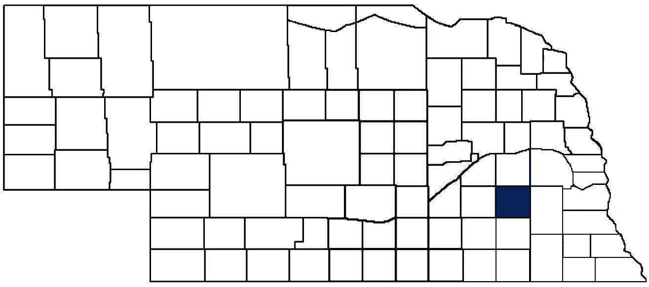
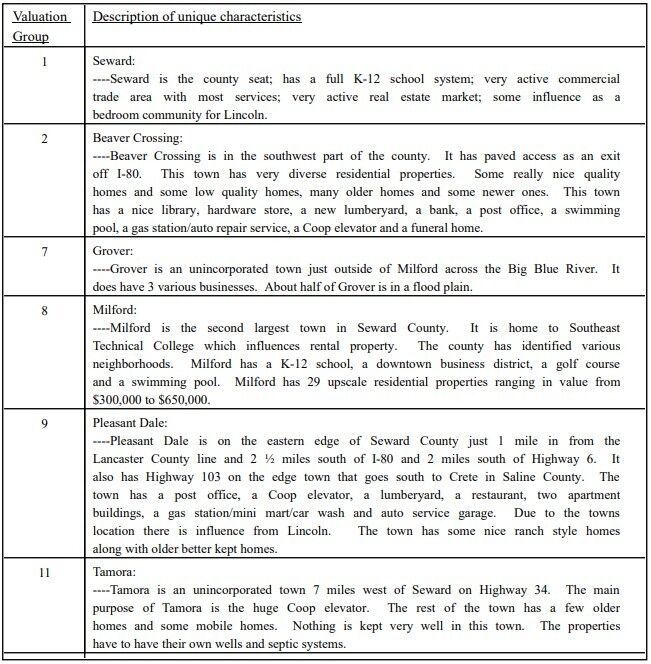
Seward County Seat: Seward
Total County Population: 17,609
- Cities (pop. & class): Milford (2,155 • 2nd Class), Seward (7,643 • 1st Class)
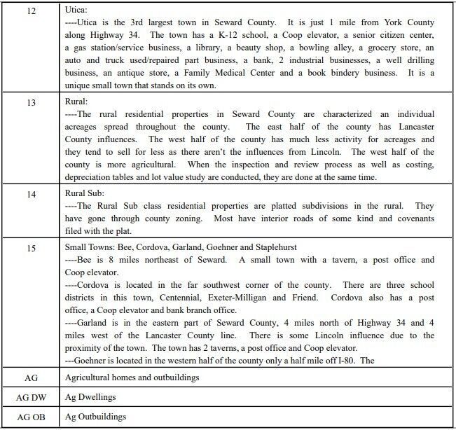
- Villages (pop.): Beaver Crossing (375), Bee (171), Cordova (92), Garland (210), Goehner (181), Pleasant Dale (218), Staplehurst (236), Utica (840)
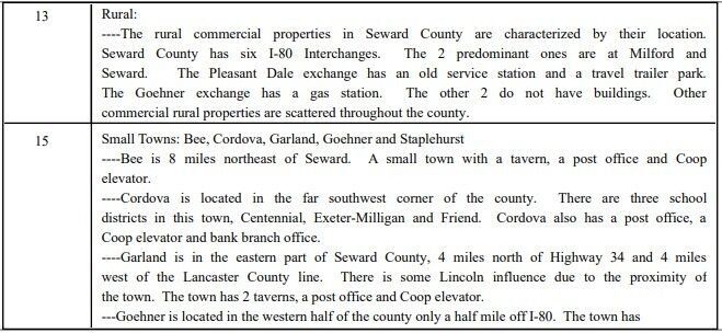
- Unincorporated Pop. (% of county pop.): 5,488 (31%) 2020
Land Development (% of total land in county):
- Agriculture: 83%
- By method: Irrigated (row crop/grain/forage) (40%); Dryland (row crop/grain/forage) (32%); Pasture (pure grassland) (12%) • Neb. Dept. of Rev. - total equals agriculture's %
- By commodity: Corn 40%, Soybeans 32%, Livestock (grassland) 13%, Alfalfa 1%, Other Hay 1% • USDA - equals agriculture's % plus some wetlands (1%) and minus public grassland/wetlands and reserve
- Residential, Commercial, Industrial, Conservation Reserve & Exempt (combined): 16%
- Timber: 1% 2022
County Offices
Courthouse Address and Hours:
529 Seward Street
Seward, Nebraska 68434
M-F 8:00 am - 5:00 pm
Complete list of county board members
County Board Meetings: Tuesday
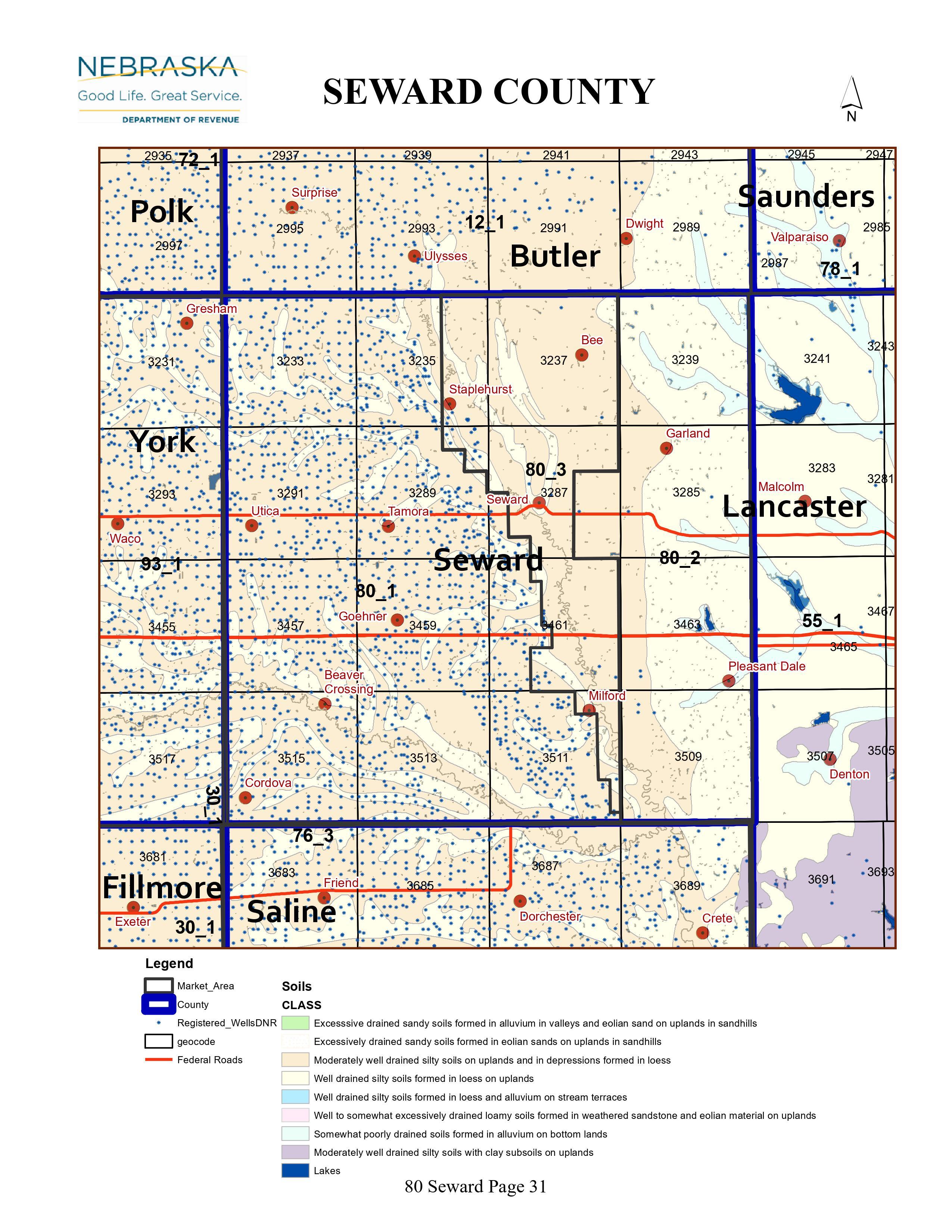
View the County's Government Maps
NACO District: Southeast
Click for a live look at Seward County (north of Pleasant Dale)
General
Population: 17,609
Land area (sq. mi.): 571.43
Population per square mile: 30.8
Race & Age
Race 2020
White: 93.0%
African American: 0.6%
American Indian: 0.2%
Asian: 0.3%
Hispanic: 2.8%
Native Hawaiian and Pacific Islander: 0.0%
Two or More Races: 2.7%
Age 2020
0-17: 23.5%
18-64: 58.8%
65+: 17.7%
Households
Total households: 6,558 2020
With one child: 730 2022
With 2+ children: 1,270 2022
With seniors (65+): 1,880 2022
Socioeconomics
Median household income: $81,122 2023
% of Population in Poverty: 7.6% 2023
# of Housing Units: 7,061 2020
2023 housing unit building permits: 54
Owner-occupied rate: 74.4% 2020
Median home price: $248,600 Q4 2024
2024 building permits for detached single family homes: 46
2024 building permits for non-detached housing units: 48 (townhouse, duplex, or apt. unit)
Technology
Access to broadband (100 Mbps via fiber or cable modem): 74.0% 2021
Sources: National Association of Realtors, Nebraska Department of Revenue, Nebraska Legislature, Nebraska Library Commission, U.S. Bureau of Economic Analysis, U.S. Census Bureau (building permits), U.S. Census Bureau (demographics), U.S. Census Bureau (municipalities)
Employment, Schools, and Child Care
Unemployment rate: 2.3% March 2025
County Employment Website: https://www.sewardcountyne.gov/humanresources
High school graduate or higher: 94.7% 2020
School Districts: Centennial Public Schools, Crete Public Schools, David City Public Schools, Dorchester Public Schools, East Butler Public Schools, Exeter-Milligan Public Schools, Friend Public Schools, Malcolm Public Schools, Milford Public Schools, Raymond Central Public Schools
Bachelor's degree or higher: 30.7% 2020
Community College Service Area: Southeast Community College
Countywide child care capacity: 26 providers; 1,019 children 2024
Find child care: For a list of child care providers in your zip code, visit Nebraska DHHS or the Nebraska Resource and Referral System.
Seward County Economy
Annual Gross Domestic Product (GDP): $1,060,423,000 2023
Nonfarm Small Business Receipts: $131,764,311 2022
Nonfarm Wage Income: $422,528,000 2022
Farm and Ranch Commodity Sales Receipts: $388,829,000 2022
Farm and Ranch Operations (Non-Sales) Receipts: $21,937,000 2022
- For components of nonfarm small business receipts, nonfarm wage income, and farm & ranch commodity sales and operations receipts, see "Notes" below.
Grain Elevators by Location (bushel capacity):
- Bee: CVA (1,511,000)
- Cordova: Farmers (1,390,486)
- Milford (between Milford and Seward): Farmers (4,115,768)
- Pleasant Dale: Farmers (779,497)
- Tamora: CVA (5,736,000)
- (1 bushel = 56 lbs. corn/sorghum, 60 lbs. soybeans/wheat; % max. moisture = 18% beans, 15.5% corn, 14% sorghum/soybeans, 13.5% wheat)
Railroad Miles: 70.41 main, 5.55 side
- Places with Railroad Service: Milford, Pleasant, Staplehurst, Tamora, Utica
Local Grain Market: Click for today's grain prices in Seward County
Cattle Producers: 245
- Pastureland Cash Rent (avg.): $47/acre
Crop Producers: 235
- Dryland Cash Rent (avg.): $188/acre
- Irrigated Land Cash Rent (avg.): $300/acre
Dairy Producers: 5
Farmers Market: Seward Farmers Market (May - October, Wednesdays s and Saturdays 5:00 - 7:00 PM and Saturdays, 8:00 AM - 12:00 PM)
Electricity Providers: City of Seward, Nebraska PPD, Norris PPD, Perennial PPD
Wind Turbines Operating (MW): 1 turbine (1,700 MW total)
Irrigation and Drinking Water
Rural Irrigation Wells: 1,487 2024
Rural Livestock Wells: 84 2024
Rural Commercial/Industrial Wells: 10 2024
Rural Drinking Water Wells: 935 2024
Drinking Water Utility Connections: 4,288 Residential; 576 Commercial; 0 Industrial 2024
Surface Water Diversions (Irrigation): 352 2024
Click for real time:
Streamflow data on the West Fork of the Big Blue River near Dorchester
Notes
Seward County Economy
- Nonfarm small business receipts are reported by partnerships and sole proprietorships. They do not include receipts reported by cooperative associations.
- Nonfarm wage income is reported based upon the wage earner's residential address; therefore, it also includes wages earned by Seward County residents in other counties or states, but it excludes wages earned in Seward County by residents of other counties or states.
- Nonfarm wage income excludes wages earned by anyone claimed as a dependent.
- Farm and ranch commodity sales receipts and operations receipts are reported based upon the farm or ranch owner's principal county of operations; therefore, those figures also include receipts reported by producers operating principally in Seward County for their production in other counties or states, but the figures exclude receipts reported for production in Seward County by producers operating principally in other counties or states.
Irrigation and Drinking Water
- A rural irrigation well is any well intended for irrigating crops that, either on its own or as part of a set of commingled wells, is capable of pumping more than fifty (50) gallons of water per minute (gpm). Note that some rural commercial/industrial wells are also capable of pumping more than 50 gpm. In Nebraska, the owner of any well--or set of commingled wells--that is capable of pumping more than 50 gpm must register the well(s) with the state government and have a permit for the well(s) from the local natural resource district (NRD).
- Rural livestock wells and rural drinking water (also known as "domestic") wells are not allowed to pump more than 50 gpm unless permitted by the local NRD. Each rural drinking water well usually serves one single family home, though in rare cases a rural drinking water well serves multiple homes.
- Data on rural livestock wells and rural drinking water wells may be incomplete for wells drilled prior to September 9, 1993. State law does not require wells drilled prior to that date to be registered with the state government if the wells are not capable of pumping more than 50 gpm. Neb. Rev. Stat. § 46-735; see Laws 1993, LB 131, § 25.
Click the section numbers in the grid below the map for annual groundwater levels.
Note: Geocodes in the map's squares are in the grid next to Township & Range (T&R).
Sources: National Agricultural Statistics Service (USDA), Nebraska Cooperative Council, Nebraska Coordinating Commission for Postsecondary Education, Nebraska Department of Health and Human Services, Nebraska Department of Revenue, Nebraska Department of Transportation, Nebraska Office of the CIO, Nebraska Power Review Board, Nebraska Public Service Commission, U.S. Bureau of Economic Analysis, U.S. Bureau of Labor Statistics, U.S. Census Bureau, U.S. Energy Information Administration, U.S. Department of the Treasury (IRS), Warehouse and Commodity Management Division (USDA)
2024 Levies and Valuation
County levy rate: $0.2727 per $100 of taxable valuation
County property taxes levied: $10,325,308
Total local government property taxes levied: $46,093,491
Total countywide taxable valuation: $3,785,909,138
Federal PILT payment to Seward County (FY2024): $2,287 regarding 683 federally-owned acres
Click here for all levy rates in Seward County
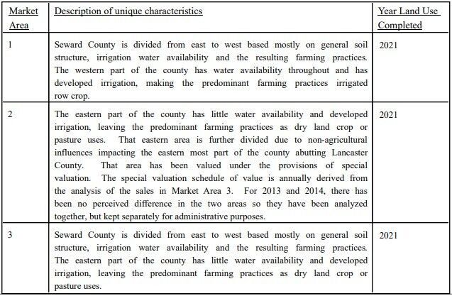
Agricultural Land Valuation Market Areas
Commercial Land Valuation Groups
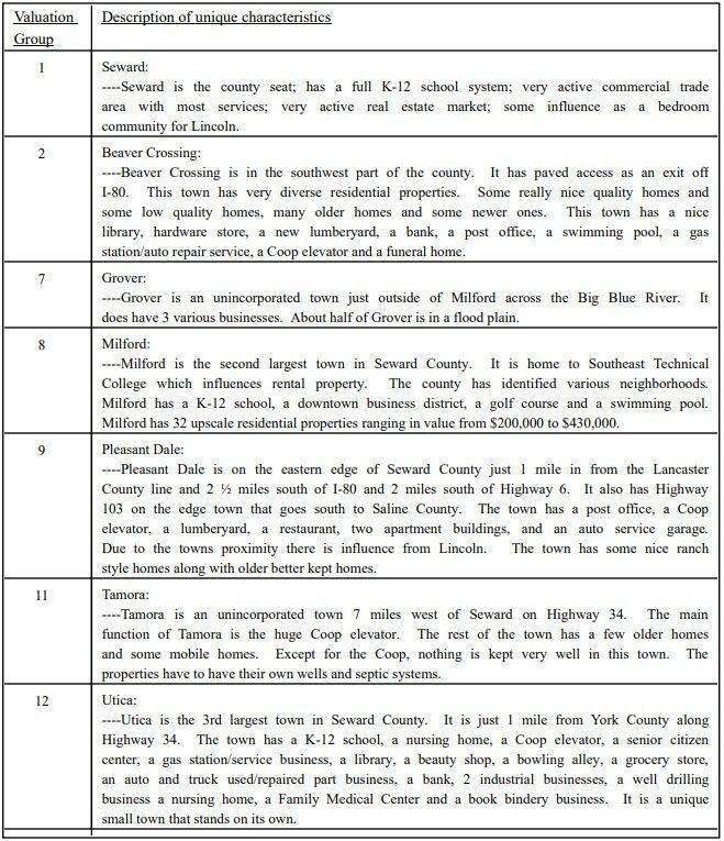
Residential Land Valuation Groups
County Levy and Taxation Laws
Levy limits
Since 1996, counties and other political subdivisions have been subject to the levy limits listed in Neb. Rev. Stat. § 77-3442 and Neb. Rev. Stat. § 77-3443.
Statutes and regulations
Nebraska Revised Statutes (Chapter 77)
Nebraska Administrative Code (Title 350)
Local tax reductions, exemptions, and credits
Neb. Rev. Stat. § 76-902(5)(a) (Deed "stamp tax" exemption): "The [stamp tax] shall not apply to: ... (5)(a) Deeds between spouses, between ex-spouses for the purpose of conveying any rights to property acquired or held during the marriage, or between parent and child, without actual consideration therefor."
Neb. Rev. Stat. § 77-201(2) (Valuation of agricultural land and horticultural land): "Agricultural land and horticultural land as defined in section 77-1359 shall constitute a separate and distinct class of property for purposes of property taxation, shall be subject to taxation, unless expressly exempt from taxation, and shall be valued at seventy-five percent of its actual value, except that for school district taxes levied to pay the principal and interest on bonds that are approved by a vote of the people on or after January 1, 2022, such land shall be valued at fifty percent of its actual value."
Neb. Rev. Stat. § 77-6703(1) (Tax credit for school district taxes paid): "(1) For taxable years beginning or deemed to begin on or after January 1, 2020, under the Internal Revenue Code of 1986, as amended, there shall be allowed to each eligible taxpayer a refundable credit against the income tax imposed by the Nebraska Revenue Act of 1967 or against the franchise tax imposed by sections 77-3801 to 77-3807. The credit shall be equal to the credit percentage for the taxable year, as set by the department under subsection (2) of this section, multiplied by the amount of school district taxes paid by the eligible taxpayer during such taxable year."
Sources: Nebraska Department of Revenue
State Senator: Jana Hughes (District 24)
Committees
- Education
- Natural Resources
- Building Maintenance
- Education Commission of the States
- Midwestern Higher Education Compact Commission
Map and statistics for Legislative District 24
Map of all districts in the Nebraska Unicameral Legislature

Seward County History
Number of Registered Historic Places: 9
Year Authorized: 1855
Year Organized: 1865
Etymology: William Seward (U.S. secretary of state)
The boundaries of what today is Seward County were defined by the Territorial Legislature on Jan. 26, 1856. The original name given to the county was Greene, after a Gen. Greene of Missouri. But when the Civil War broke out Gen. Greene joined the Confederacy so on Jan. 3, 1862, members of the Territorial Legislature voted to rename the county in honor of William A. Seward, Secretary of State under President Abraham Lincoln.
County organization began in 1865, but it was not until 1871 that a county seat was selected. The townsites of Seward, Milford and Camden each sought this honor. As can best be determined, the "election" that followed was simply a matter of "Seward, yea or nay." To quell any objections to the "election," a frame building was quickly put up to serve as a courthouse.
A unique part of Seward County's history was the development of the present courthouse and the benefactors who contributed to it.
As the number of county records accumulated, it became apparent that a larger fireproof building was needed. Several times between 1879 and 1900 the idea was proposed, but each time it failed due to the anticipated cost. In 1900, Lewis Moffitt, who owned the land on which the city of Seward is located, died. Moffitt's will stated that upon the death of his wife, Mary, his land should be sold and the money be used to build a courthouse and jail at a cost of not less than $100,000.
By 1904 a campaign was well under way to build the courthouse that Moffitt had envisioned. On Sept. 20, 1905, the cornerstone was laid amid a festive celebration that attracted what was estimated at between 8,000 and 10,000 people. As construction progressed there were numerous suggestions on how the county could show its appreciation to the Moffitts. Some even suggested renaming the county in their honor. It was ultimately decided that a plaque honoring the Moffitts be installed inside the courthouse. In 1980 the impressive building and tree-lined courthouse square that were the result of Moffitt's early vision celebrated its 75th anniversary.
Highlight an important program in your county in this space! Send an email to:
Local Highlights
License Plate Number: 16
Time Zone: Central
Number of Veterans: 1,051 2023
Zoned County: Yes
Number of County-Owned Bridges: 183
Number of County-Owned Dams: 6
Election Data
General Election Turnout: 80% 2024
Total Registered Voters: 11,599 2024
Number of Precincts: 16 2022
Number of Election Day Polling Places: 11 2022
Land Area per Polling Place: 52.35 sq. miles
Intergovernmental Data
Emergency Mgt. Planning, Exercise and Training (PET) Region: Southeast
Natural Resources Districts: Lower Platte South NRD, Upper Big Blue NRD
State Lands (acres): Blue River Rest Area EB (17.3), Blue River SRA (14), Branched Oak WMA (2,865.56 Lancaster & Seward), Burr Oak WMA (138.50), Goehner Rest Area WB (9.3), Oak Glen WMA (632.58), North Lake Basin WMA (364), Panhandle Research, Extension and Education Center (156), Shypoke WMA (160), Straight Water WMA (240), Twin Lakes WMA (1,270)
Federal Lands (acres): Freeman Lakes WPA (350 Seward & York), Tamora WPA (283.38)
Sources: Nebraska Department of Transportation, Nebraska Emergency Management Agency, Nebraska Game & Parks Commission, Nebraska Legislature, Nebraska Office of the CIO, Nebraska Secretary of State, U.S. Department of Veterans Affairs, U.S. Election Assistance Commission, U.S. National Archives and Records Administration (eCFR)